


1. Click the Site Info button in the Display Control Bar

2. Move the mouse pointer to where you want the information for on the map. Click to display the information for that point:
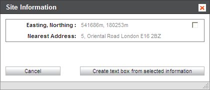
If you are viewing a VML Raster, OS Detail or Aerial layer you will be provided with the following information:
•Easting and Northing (m): The Easting and Northing co-ordinates will be supplied
•Nearest Address: The nearest address to the point you clicked on the map will be displayed
If you are viewing a UKMap detail map you will be provided with the following information:
•Easting and Northing (m): The Easting and Northing co-ordinates will be supplied
•Unique Feature Ref: Every feature on the map has a unique reference, so if you need to ask us a question about a specific feature you can use this number to identify the feature you are looking at.
•Last Update: Last Update provides you with the date the feature was last updated, or if it is a new feature, when it was created.
•Unique Source: This information will tell you how the information on the map was obtained. This will be displayed as one of the following:
•Aerial survey - full refly: This means that an entire area, such as the whole of London, was completely re-flown to obtain the information on the map.
•Aerial survey - local update: This means that only a small area was re-flown, possibly due to cloud on the original photographs, to obtain the information on the map.
•TGG QA Edit: This means that information on the map had been updated in response to some direct feedback either from a customer or from a "registered change partner" such as Promap.
•Land Use: This will provide you with the current Land Use for the point on the map you have clicked on.
•Feature Type: This will tell you what type of feature you have clicked on.
•Point Of Interest: If the point on the map that you have clicked on is a Point of Interest, then the name of it will be displayed here.
•Retail Name: If applicable, this will provide you with the name of the shop.
•Retail Classification: If applicable, this will display what type of retail takes place at the point on the map you have clicked on.
•Nearest Address: The nearest address to the point you clicked on the map will be displayed
•Building Height Metres: All permanent buildings on the map have a height value and this will be displayed in metres.

See Also
To annotate a map with site information
To annotate a map with a text box showing measurements