


1.Locate your site. See To locate a new site for information.
2.Click the Historical Maps toolbar ![]() .
.
3.The Historical map ordering steps will be displayed:
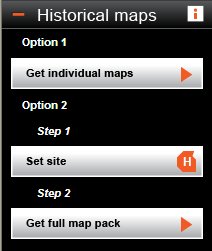
4.Ensure your map is centered on the site you are interested in by right clicking on your site of interest in the map.
5.Click the Get individual maps button ![]()
6.The Landmark Historical Mapping page will open. This page will display every historical map available for the site you have specified. We also supply the following information about each historical map:
Information |
Description |
|---|---|
Date(s) |
The epoch or time period that the map was created. Historical map data is available for different time periods referred to as epochs. These epochs roughly equate to the first County Series survey, and subsequent revisions, and the first National Grid resurvey and subsequent sheet revisions. Not all areas will have mapping available for each epoch as the number of revisions for each county varies. |
Price |
The price of the historical map |
Survey Scale |
The original Ordnance Survey scale of the historical map. Landmark Historical maps are not plotted to their original scale when printed from the A3 PDF or GIF files supplied. |
Coverage |
Tells you how much of the site is covered by the map offered. If the coverage is less than 100% then you should view the preview available to ensure that you are happy with the map available. |
Preview |
We recommend that you check the previews supplied for suitability before purchasing your historical maps. The majority of historical mapping is in excellent condition resulting in clean line work and backgrounds. However, a number of factors affect the quality of the scanned image. For example ingrained dust on the maps, in a small proportion of cases, resulted in dark areas. The paper of some maps has become slightly distorted, affecting the overall geometry of the map; this is especially the case with the 1:10 560 scale County Series maps. As a result, these maps are not perfect rectangles and once de-skewed there may be some loss of data and a less than perfect join when the maps are lined up. However, this category of maps is a small proportion of the total. |
7.To order the historical maps you want, click the tick boxes provided next to each historical map entry to select them. Once selected, the chosen maps will turn a darker shade of blue.
You can see the total number and the total cost of the maps selected on the right of the page in the Totals box.
8.Next to Create my maps as: choose whether to download the map as a pdf or a gif.
9.Before you buy your historical maps you must accept the Terms and Conditions. The check box is already ticked for you. If you would like to read the Terms and Conditions, click the words Terms and Conditions.
10. Once you are ready to purchase your maps click Buy Historical Maps.
11. The Expenditure Details popup box will appear to warn you that you are about to do a chargeable action. Enter a Project and Reference for your historical maps and these will be entered into your accounting files. Click OK.
Promap displays the Map Generation page whilst it downloads your file. If you have made multiple purchases, Promap compiles all your historical maps in to a single zip file for ease when saving. An Order Summary is also displayed on this page for you. Once the generation is complete you will see 100% appear next to a blue line.
12. You are now ready to save your historical maps. Please go to To save your historical maps.
We strongly recommend that you save your historical maps to your computer before exiting Historical Maps. Once you have exited the historical map section your maps are discarded and you will not be able to retrieve them at a later date. Historical maps are not saved within Promap in any format.
An email is also sent to the email address registered to the users account with a link to download the files in the event the user cannot download them from the website. This link is valid for seven days.
See also