Promap Functionality
Through the viewable data layers monthly subscription this dataset can be overlaid onto the OS Openmap, Aerial. OS Vectormap Local and OS
Mastermap topography layers, included in prints and the data exported to a CSV file. The data is also utilised for the Landsearch and Sitecheck Assess reports available from Promap.
What does it provide?
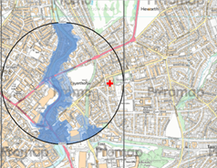
These flood zones illustrate the probability of flooding from rivers and the sea and ignore the presence of any flood defences. This dataset is derived from the flood zones of the relevant environment Agency’s flood map, a multi-layered product highlighting areas that could be affected by flooding. Flood Zone 2 shows the additional extent of an extreme flood from rivers or the sea. These outlying areas are likely to be affected by a major flood, with up to a 0.1% (1 in 1000) chance of occurring each year. Data is only available in England and Wales.
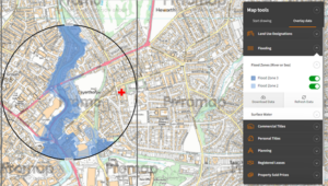
Dataset Name : Flood Zones
Supplier : Environment Agency
Coverage : England and Wales
Update Cycle : Quarterly
Free or Subscription: Free within Promap
See samples of the Flood Zones data in action in :
Landsearch – Click Here
Sitecheck Assess – Click Here
Viewable Layers – Click Here