Since we launched Promap v2 in 2018, we’ve been continually adding new features to make it better than ever. Below are some of the great new benefits we’ve added over the last few months, but we’re not stopping there, so be sure to follow us on Twitter and LinkedIn to stay up to date with the latest enhancements.
Overlay key information
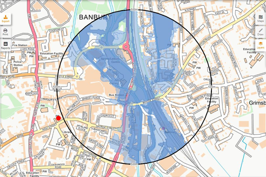
You can now view a range of different data layers on your site maps, including:
• Flooding (EA Flood Zones 2 & 3 and Surface Water Flooding – 30, 100 and 1,000 year return periods.)
• Ownership (Land registry corporate and overseas corporate ownership information.)
• Land Use Designation (Local Development Plans split into ‘recent’ and ‘older’, with 11 different land use types.)
Print out key data layers
Not only does Promap v2 give you the ability to view essential data layers on screen; but you can now print them out too. This feature gives great context for site scoping or an investigation piece, by providing supporting evidence.
Quickly find the map you’re looking for
We’ve updated the ‘Open Maps’ and ‘Save Maps’ area with a date filter. This speeds up the process, since Promap v2 only retrieves the last two years of saved maps, and makes searching for the right map even easier. If you want to go back further, use the existing search tool or select the desired date range to easily find the map you’re looking for.
Draw shapes quicker
When drawing a shape, the segment length is now shown on the ‘active line’, enabling you to easily note the lengths of the different edges of your shape.
Save grouped shapes for next time
It’s now possible to add grouped shapes to your drawing library, enabling you to save complex geometries for use on other maps, without having to draw them again.
Set your default task
You can now choose your preference between the key tasks in Promap v2: Export, Print or Report. It’s only a little thing, but it will help you work quicker.
Display the nearest address
It made sense to move the ‘site information’ button to the footer, next to the ‘site marker’ button. Click on it (and then your map) to display the nearest address, along with the Eastings and Northings.
To try all the latest Promap v2 features, visit https://www2.promap.co.uk/.